The Assessment of Reconstruction Approaches in Exposed Villages to Rockfall: Resettlement or not (Case Study: Alishahi and Meydan Villages, Fars Province, Iran)
Mohsen Sartipi ÂÂ Pour1 and Soheil Mahmoodi2 *
1
Department of Architecture,
School of Architecture and Urbanism,
Tehran
Iran
2
Master of Reconstruction after Disaster,
Shahid Beheshti University,
Tehran
Iran
http://dx.doi.org/10.12944/CWE.10.Special-Issue1.73
This survey studies the major cause of landslides and assesses the main reconstruction approaches after occurrence of such disasters. The main purpose is to find the key factors which influence determination of built in-place or relocating the prone villages. In Jan 2011, after an earthquake took place in Alishaahi and Meydan -the villages of Fars province- two different decisions were resettlement and build in-place of them. They were both equally based on their geographical location, context, culture and threat type though. In this research the major factors of such decision making will be studied and compared. This study is qualitative research which concerns the comparison of data. This research goes through, literature reviews, documentation. The most important data collection methods in this paper are direct observation of the data, review of documents and in-depth interviews with experts and victims. Finally, it is concluded that different factors will affect the decision making approach.
Copy the following to cite this article:
Pour M. S, Mahmoodi S. The Assessment of Reconstruction Approaches in Exposed Villages to Rockfall: Resettlement or not (Case Study: Alishahi and Meydan Villages, Fars Province, Iran). Special Issue of Curr World Environ 2015;10(Special Issue May 2015) DOI:http://dx.doi.org/10.12944/CWE.10.Special-Issue1.73
Copy the following to cite this URL:
Pour M. S, Mahmoodi S. The Assessment of Reconstruction Approaches in Exposed Villages to Rockfall: Resettlement or not (Case Study: Alishahi and Meydan Villages, Fars Province, Iran). Special Issue of Curr World Environ 2015;10(Special Issue May 2015).
Available from: http://cwejournal.org?p=637/
Download article (pdf)
Citation Manager
Publish History
Introduction
Slope failure or landslide is a combination of outer or inner factors which leads to breaking the stones and involving the movement of earth, rock or debris down slope under the influence of gravity. (Shaker et al., 2005)
Iran with a mountainous geography seismic activity and various geology and geography aspects is hugely vulnerable to landslides. Landslide as a natural disaster annually causes lots of deaths and damages through the country, 32000 landslides have been declared so Far. (Taghipur, 2012)
Relocation is one of the usual policies which are imposed after occurring natural disasters through the urban or rural areas in developing countries.(Badri et al. 2006) Researches, regarding relocation, have revealed the fact that reconstruction in a new site has deeply influenced the affected society and their dissatisfaction. The worst scenario is displacement of the survivors. (Zargar,2005), (Barakat,2003) Relocation, either in programming and planning phase or construction phase can cost a lot of expenses and will definitely affect the divested society economically, socially and emotionally either in short time or long time period.. (Barakat, 2003), (Davis, 1978)
The relocation can cause serious problems, for each society is dependent on its relatives, customs, life style, safety and historical cultures of their residence; however, sometimes this relocation is inevitable and if done, it should be imposed with close attention. This issue can be temporary or permanent solution. (Fallahi, 2007) Considering the different aspects of relocation or not, we can come to the conclusion and avoid any risks regarding susceptible landslides. Then we can take huge steps in rehabilitation after landslide disasters and sustainable development of the mountainous areas. (Mahmoodi, 2015) Through this research, we first elaborate what we mean by relocation and its primer conditions and then the natural disaster e.i. landslide and its various types. Finally the case study will be studied intently and also its results will be analyzed.
Relocation
Relocation is defined as a process whereby a community’s housing, assets, and public infrastructure are rebuilt in another location.(World Bank, 2010) The world bank defines Displacement as "Displacement may be either physical or economic. Physical displacement is the actual physical relocation of people resulting in a loss of shelter, productive assets or access to productive assets (such as land, water, and forests)”. (IFC, 2010) The various reconstruction policies are shown in the Chart 1.
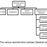 |
Chart 1: The various reconstruction policies (Garakani et al., 2010) Click here to View chart |
The Reasons for Success or Failure of Relocation
Disasters will continue to displace people, often leaving no alternative but relocation. Relocation of vulnerable communities to physically safer places is often the best way to protect them from future disasters. Some locations are inherently unsafe, e.g., floodplains, unstable hillsides, and areas where soil is likely to liquefy as a result of seismic tremors.(World Bank, 2010) Some of the reasons for the success or lack of success in displacement after disasters were discussed in the ”Safer Homes, Stronger Communities” which is gathered in a table 1. (Mahmoodi, 2015
Table 1- Successful or not in relocation approach
| Why Relocation Is Often Unsuccessful? | What makes a Relocation Successful? |
| Inadequacy of new sites | communities participate in critical relocation and implementation decisions |
| Distance from social networks | communication with target groups is frequent and transparent |
| Socio-culturally inappropriate settlement layouts | livelihoods are not site-specific and so are not disrupted |
| Lack of community participation | water, public transport, health services, markets, and schools are accessible and affordable; |
| Under budgeting of relocation costs | housing designs, settlement layouts conform to a community’s way of life |
| Distance from livelihoods | Relocation and assistance to mitigate its economic impacts are adequately funded over a reasonable period of time. |
What Is Landslide Hazard?
The landslide is a combination of outer or inner elements which lead to destabilizing soil and breaking the stones and sliding them down the steps slopes due to the gravity. Usually these moved mantle rocks flow along a Run out zone and due to some factors. (Shaker et al., 2005) Landslides occur as a result of changes, either sudden or gradual, in the composition, structure, hydrology or vegetation on a slopeThe materials that compose landslides are divided into two classes, bedrock or soil (earth and organic matter debris). A landslide may be classified by its type of movement like: Fall or Rockfall, Slides, Topples, Flows, Lateral Spreads, Earthflow, Mudflow, Debris flow, Debris avalanche. (UNDP, 2010) In this paper, Slides and Rockfall will be introduced and discussed.
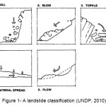 |
Figure 1: A landslide classification (UNDP, 2010) Click here to View figure |
Fall or Rockfall
Rockfall is the fastest type of landslide and is common in mountainous areas near cliffs of broken, faulted, or jointed bedrock, on steep slopes of rocky soils, or where cliffy bedrock ledges are undercut by erosion or human activity. (CGS, 2008) Many different processes cause rocks to become unstable and fall including gradual weathering and erosion, tree-root growth, and weakening of supporting rock by saturation from ground water (William F., 2000). Although the loss due to landslides is not as great and destructive as that of floods or earthquake the damage and consequent expenses in mountainous areas are inevitable.
Slides
Slides are resulting from sheer failure of soft muds along one or several surfaces. Slides material may remain intact or may break up into small pieces. (UNDP, 2010) On the other hand slides are defined as sliding smooth and soft material down the slipping steeps of hillsides due to humidity and gravity factors. The amount of the slide material is much more than those of Falls and topples thus landslides occur. (Karimi et al., 2009)
Risk Assessment Systems
There are various types of the mountain foot susceptible to slides. Thus, regarding the risk assessment system, planning a number of inter-regional comparisons and considering hazard risk are required. There are different methods in analyzing Rockfall threat among which you find: statics analysis, engineering point of view (judgment), and overlaid of GIS maps. The implementation of risk reduction measures must be preceded by locating areas prone to slope failures. The landslide hazard map (GIS Maps) permits planners to determine the level of risk (UNDP, 2010), (Mohammadi et al., 2007). The best is Rockfall Hazard Rating System (RHRS), which is totally economically and very fast to impose.
There are three possible solutions to geohazard involving Rockfalls, Remove the hazard, remove the target, or engineer an artificial support for the problem rock. There is a forth alternative, no action, but this essentially relegates the target to an unknowing game of Russian Roulette. (Cloues,2001)
These hazards are a major threat each year to human settlements and Infrastructure. This threat is sometimes caused unpleasant accident that affects the lives of many populations. So it needs mitigation and prevention plans to dispose it from vulnerable Residential areas. Then, immunization and threat disposal methods will be reviewed.(Mahmoodi, 2015), (Safarzadeh et al., 2006)
Different Methods of Prevention and Restriction
Slippery steeps generally don't meet the criteria of reconstruction and development due to the soil failure of soft muds and materials along the steep slopes, specifically in mountain areas.
Town or villages which are somehow located in mountain areas have to end are the potential high risk of slides as in Makoo-Tavan Village-Avanak, Akoojan in Almout-e-Gazvin, Taazkandy in Zanjan and historical villages of Kandovan and Kandelos in Mazandaran, Planning to avoid or mitigate on such areas is of great importance.(Mahmoodi, 2015), (Ghayumian et al., 2005)
Avoidance
Avoiding the Rockfall hazard area is the most basic method, albeit oftentimes the most difficult to accomplish. In the case of a pre-existing development or structures, the only other avoidance alternative is to move the structure out of the hazard zone, which is usually very problematic and costly. (CGS, 2008)
Protection
Protection concepts accept that Rock falls and slides are a threat to property and life within the runout zone, (ibid, 2008) but structures and roadways can be acceptably shielded from Rockfall, or sufficiently reinforced to withstand the impact without adverse damage or loss of functionality. Rockfall protection designs come in many forms. Rockfall barriers are designed to stop falling or rolling rocks. They can be constructed in the form of a large earthen wall or berm, or specialty fences built with strong, steel cable netting. Earthen barriers often include a ditch in back to provide extra space to accommodate falling and rolling rocks and associated debris.(ibid, 2008)
Earthquake Disaster on Jan 5, 2011
The earthquake hit Iran the, January 5, 2011 at 9:24:43 with a magnitude of 5.3.The closest city with more than 15.000 habitant is Nouraabad (Fars Iran), Two earthquakes measuring 5.1 on the Richter scale have jolted Iran's southern Fars Province, injuring at least eleven people. According to the Iranian Seismological Center, the quakes rocked the town of Nouraabad, triggering panic among local residents. The quakes also damaged several houses in the rural area. the authorities of Housing Foundation have announced that these earthquakes have caused tremendous damages 20% up to 80%. Fortunately, no loss of life was reported.(Mahmoodi, 2015)
Identifying the Studies Zone
Fars province is located in the south of Iran. It neighbors’ Bushehr Province to the west, HormozgÄn Province to the south, Kerman and Yazd provinces to the east, Isfahan province to the north and Kohgiluyeh and Boyer-Ahmad Province to the northwest. There are three distinct climatic regions in the Fars Province. First is the mountainous area of the north and northwest with moderate cold winters and mild summers. Secondly, the central region, with relatively rainy mild winters, and hot dry summers. The third region located in the south and southeast, has cold winters with hot summers. The geographical and climatic variation of the province causes varieties of plants; consequently, variation of wildlife has been formed in the province. (FARS Geography and History from website 2015).
Among damaged villages which were located in the mountain foot of these areas, "Meydan“ and "Alishaahi" were meant to be under further studies. "Alishaahi" and "Meydan" are two villages in Fars province, northern "Mammasani". They are located across from each other. Regarding the geological condition and location of each village watching their lifestyle and culture and social it is obvious that the Circumstances of these two villages are very analogous. Both have cold climate and mountainous weather. The unstable Sediments is prone to Rockfall hazardous areas, sharp steep slopes, and water infiltration of the soil and unsuitable pre-disaster form the material, used in building structures, are the main causes of vulnerability in the above mentioned villages.
The natural disasters such as floods, earthquake, slides, and avalanches can be a threat in these two villages. They suffered from the vast range of damage and destruction. Both villages shared the same features regarding their location in the mountain foot, also their dependency on farm lands, so they endured the same damage, considering their formation and the sort of used material in their structure noticeable likeness in inevitable. So it can be concluded that housing and farm land are function a common role thus making decisions either to reconstructing in same place or relocating could have played a significant role.
So we study them as peer models in this research to compare the efficiency of relocating or not.
Table 2: Major characterization to identify the mountainous villages (Authors)
| Subject | Criteria | Characteristic | |
| Village and rural area | context | located on steep slopes | |
| former housing | Thatch and stone | ||
| water infiltration | surface Water disposal | Using the absorption well and surface runnel | |
| soil texture | Asmari Formation and gypsum-limestone | ||
| The rainfall | Seasonal | ||
| Causes the formation of village | Social - cultural elements | Ethnicity and Dialect | |
| Accessible sources | Drinkable water, farming lands and pasture land | ||
| Livelihood | Agriculture and horticulture, animal husbandry | ||
| Natural Threating Hazards | Falls | Slopes | Location |
| Avalanche | Size and percent | ||
| slide | Runout zone | ||
| Fault | geological | ||
| Earthquake | |||
| Floods | prone to riverside | ||
| the history of disaster | debris and documents | ||
| population in risk | population of village | ||
Alishaahi village Reconstruction: Build in-Place
After the disaster, it was decided for the villagers to move to downhill and the village itself to be reconstructed in a new zone; however the villagers didn't intend to do so, because the lands and ranches in the new zone were the source of income for them. On the other hand to reconstruct the damaged village on the vulnerable former zone was not wise and also could cost a lot of expenses.
In this project, after reconsidering the aim of the reconstruction, the decisions were retaking and, plan was changed. The decision was passed to Housing Foundation. The issue was raised for Geotechnical Consultants, thus they came to conclusion that is not necessary displacing the "Alishaahi" village and it’s possible to rebuild it in the origin zone with threat disposal.
Schemes and preparations were imposed to prevent any susceptible risk or threat. Also, the residents Disapproval makes the success of project in future unclear. So after studying and observing every aspect, drainage and slop stabilization on top of the village were done to prevent landslides hazard.
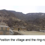 |
Figure 2: Position the village and the ring-road (Authors) Click here to View figure |
People participation in some important aspects like the decision making or Implementation phases and using Local Building materials has an important influence on the project. Regarding the affected people interest for every single family were a unique plan considered and implemented. "This plan was performed based on the geotechnical consultant and development plan designed and developed by Housing Foundation authorities for village" Housing foundation reported. A ring-road was designed and executed for soil stabilization and removal of surface waters, mitigate the landslide risk, and apply the threat prevention. The old and new village is compared in table 3.
Table 3: The compression of the old and new Alishaahi village
| After reconstruction | Before reconstruction | Architectural elements |
| Easy access to the spaces, extraversion Plan | Easy access to the spaces, extraversion Plan | Housing |
| Bricks and blocks joists and stone facade - Brick | Stone and brick and beams and thatch | Materials |
| Concrete bearing walls | No Structure | Structures |
| Dense | Dense | context |
| Diversity of obstruction matching to the slope of the mountain | Diversity of obstruction matching to the slope of the mountain | pathway |
| avalanches, drought | Rock falls, landslides, avalanches, drought | Risks and threats |
| suit the land slope | suit the land slope | Rural landscape |
| Separated | Separated | Animal and human |
| Do Exist | Did not exist | Sense of safety |
| Participation in decision-making, planning, debris removal, implementation and monitoring by residents | Gradual formation of village without government intervention and the use of local knowledge by residents | people Participation |
| animal husbandry and agricultural and tourism | animal husbandry and agricultural | Livelihood |
"Meydan Village" Reconstruction: Relocating
After to the earthquake strike and severe loss and the devastation occurrence in the countryside, some experts were sent out to investigate the situation. After the initial investigation suggested the same way with the “Alishaahi village” propounded. This suggestion was rejected from the local people point of view. Some reasons are mentioned as follows:
- Being insecure about the practical functioning of the ring-roads.
- Being insecure about incapability of the experts regarding the safety issue and avoiding the risk of further falls.
- Being insecure about insufficient budgeting to build bracings.
- Feeling insecure about being in a threatened mountain foot zone again.
- Not enduring living in the old place and lack of facilities and services.
Villagers were insisting on relocating their habitation. After lots of discussion between them and the Alderman about choosing the new location and how to provide the expenses, the new purchased piece of land was offered to (HF).1 The new location was 500m farther than the old one; thus villagers could afford it. Other pieces of lands were either not released for sale due to their farming function or their high prices[2]or not affordable.
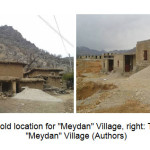 |
Figure 3: left: The old location for "Meydan" Village, right: The new location for "Meydan" Village (Authors) Click here to View figure |
Reconstruction of those village after constructing all the buildings in the new location was carried on to the end process of structure, but the inner and outer facades was left to be undertaken by villagers rather than housing foundation. Yet, the villagers haven't moved to new location after four years. When interviewed and asked they mentioned some reasons as the slight falls and slides due to improper substructures in the new site also feeling unsecured regarding slides and other natural disasters and no sense of belonging. Besides some advantages of using modular houses and 60metre typical building of steel structures and bolts in the whole disaster prone (fast reconstruction), there are some disadvantages too. You can follow them in the table (4).
Table 4: The compression of the old and new Meydan village
| New village | Old village | Architectural elements |
| Module plan, Easy access to the spaces, extraversion Plan | Complex and Introspective Plan | Housing |
| Concrete block and brick-stone facade | Stone and brick and beams and thatch | Materials |
| The steel frame and bolts | No Structure | Structures |
| lengthy structure,without sub-streets | Dense | context |
| A flat, low slope site and | Diversity of obstruction matching to the slope of the mountain | pathway |
| Landslides Earthquake, Flows | Rock falls, Landslides, Avalanches, Earthquake, | Risks and threats |
| Module and a typical buildings | suit the land slope | Rural landscape |
| Has not stable | Separated | Animal and human |
| Due to the recent events does not exists | Because of falling, Does not exist | Sense of safety |
| People not involved in designing the building plan Participation in the new Site Selection, purchasing land ، Implementation and monitoring restricted by residents | Gradual formation of village without government intervention and the use of local knowledge by residents | people Participation |
| animal husbandry and agricultural and tourism | animal husbandry and agricultural | Livelihood |
Comparing Reconstructions
Comparing reconstruction of both “Alishaahi” and “Meydan” villages based on their similar factors such as the threats, village context, and the impact and effect of disaster, it can be noticed that two incompatible decisions have been made whereas both were sharing similar circumstances. Based on this comparison, we conclude that there were some common factors and criteria, if not brought into consideration, can lead to relocation and resettlement, which is not desirable and will have regrettable consequences.
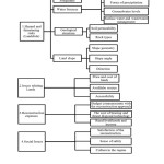 |
Chart 2: Effective Elements to make the decision in landslides-prone sites Click here to View chart |
Conclusion
The Fars earthquake and rockfall occurred on the 6th of March 2013. Generally speaking, it can be concluded that “Alishaahi” reconstruction process in the origin site has shown that relocating decision in a new site after the Rockfall and slide disaster is not only choice. So we'd better look forward to finding and studying better approaches for reconstructing affected rural areas in their origin zone site which is really more practical and logical even if it carries high expenses at more the beginning Rather than moving and relocating them. Threat disposal and life safety is of great importance then. Finally, effective elements to make the best decision either to reconstruction in the former place or relocating and moving the affected Set are shown in the chart 2.
This chart shows that each element has various sub conditions which are related to other elements. Rockfall and landslide as hazards can be a main part of the study program, which should be considered more in geological aspects. Land issues are playing a significant role in reconstruction expenses. Also, social and cultural conditions have an influence on reconstruction decisions which can affect the rehabilitation in the long term.
References
- Shaker M.;Jabbari M.; Haidar F.;, the necessity of zoning unstable slopes(Case study:Zoning unstable slopes with in the university), Second Rescue Management Conference, Tehran, Iran University of Applied Science Iranian Red Crescent, (2005).
- Taghipur, S.; predicted by the Italian Civil Engineers landslide, Shakhes Pajouh Journal- 4 - Special Hazard Land, 18, (2012).
- Badri, S. A.; Asgary, A.; Eftekhari, A.R.; Levy. J. Post-disaster resettlement, development and change: a case study of the 1990 Manjil earthquake in Iran. Disasters, 30, 451–468 (2006)
- Zargar, A, Introduction to the understanding of rural architecture, Tehran (Shahid Beheshti University,. 2005)
- Barakat, S., Housing Reconstruction after conflict and disaster, Humanitarian practice network paper, publish and demand LTD London, 43 (2003)
- Davis I., shelter after disaster, oxford university press, (oxford,1978)
- Fallahi, A., "An Architecture for temporary settlements after disasters" Shahid Beheshti University, Tehran, 79-80 (2007)
- Mahmoodi, S, Comparative Approaches"Build in-placeby removing the threat" with relocation Fars province after the earthquake 1389(Case Study: Alishaahi and Meydan ), Dr. Srtipipour, Eng.H.Miri, Shahid BeheshtiUniversity,Tehran, 6-8 (2015)
- World Bank, Safer homes, stronger communities: A Handbook for Reconstructing after Natural Disasters, 77-80 (2010).
- International Finance Corporation (IFC). Environmental and Social Development Department. Handbook for Preparing a Resettlement Action Plan. Washington, DC: World Bank. (2002)
- Garkanih.; RustayiH.F.; MokhtabadM.; Ward R.F.,"Analysis of transformation of rural settlement sign" Baba Pashman village"after shifting the emphasis on indicators of housing," Azad University, Science and Research, 8(25), 187-202 (2010).
- UNDP, Introduction to Hazards, Disaster Management Training Pro., 3rd edition, 57-58 (1997)
- Colorado Geological Survy (CGS), Rock Talk, Rockfall Colorado, 11, 3-11(2008).
- William F. Rock-Fall Hazards, Case: Utah Geological Survey Public Information Series 69، ugs.state.ut.us. 1-15 (2000).
- Karami, F.; Rajabi, M. Evaluation of landslide hazardan drisk analysis of the case study in rural areas: the northernslopes of Sah and Mountain, Journal of Geographical Society, 19, 18 (2009).
- Mohammadi, ;Mazallhy. A.;Bahrami A., To evaluatethe likelihood of occurrence ofrock falls(Rockfall)in the highlands Alzaman Kerman, Natural Disaster Conference, Center of Excellence in Disaster Management and Surveying Engineering, Faculty of Engineering Tehran University,2 (2007).
- Cloues, F., Geohazards and risk: Rock mechanics assessments, geologic Resources Division, report- national park service, p 15 (2001).
- Safarzadeh, ;AsdamrjyM., A method of preventing or reducing accidents caused by the earthquake falling on mountain roads, the Seventh International Congress on Civil Engineering, Tarbiat Modarres University, Department of Civil Engineering, Tehran, P 2 (2006).
- Ghayumian, C.; M. Fatemi.; Aghda, Atai ; David M. E., A decision support system to determine the appropriate method of dealing with a landslide (case study: Landslide narrow (third national conference on erosion and sedimentation,, Soil Conservation and Watershed Management Research Center, Tehran p. 5, (2005).
- FARS Geography and History from website http://www.irantour.org/Iran/city/FARS.html (2015)


